
Thank you for supporting this site ❤️
Make a donation
Make a donation
Khaplu topographic map
Click on the map to display elevation.
Thank you for supporting this site ❤️
Make a donation
Make a donation
About this map
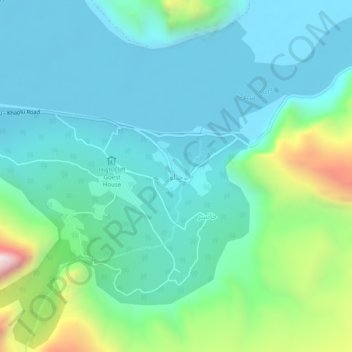
Name: Khaplu topographic map, elevation, terrain.
Location: Khaplu, Ghanche District, Gilgit-Baltistan, 16810, Pakistan (35.14350 76.32415 35.18350 76.36415)
Average elevation: 2,659 m
Minimum elevation: 2,466 m
Maximum elevation: 3,383 m
Thank you for supporting this site ❤️
Make a donation
Make a donation
Other topographic maps
Click on a map to view its topography, its elevation and its terrain.