
Barrancas topographic map
Interactive map
Click on the map to display elevation.
About this map
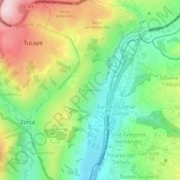
Name: Barrancas topographic map, elevation, terrain.
Average elevation: 888 m
Minimum elevation: 749 m
Maximum elevation: 1,105 m
Other topographic maps
Click on a map to view its topography, its elevation and its terrain.
Palo Gordo
Venezuela > Estado Táchira > Municipio Cárdenas
Palo Gordo, Parroquia Amenodoro Rangel Lamús, Municipio Cárdenas, Estado Táchira, 5017, Venezuela
Average elevation: 1,002 m