
Make a donation
Mosquera topographic map
Click on the map to display elevation.
Make a donation
Mosquera
Mosquera is a municipality of Colombia in the Western Savanna Province, part of the department of Cundinamarca. Mosquera is close to the capital Bogotá and is part of its metropolitan area. The urban centre of Mosquera is situated at an altitude of 2,516 metres (8,255 ft) on the Bogotá savanna. The municipality borders the localities Bosa and Fontibón of Bogotá in the east, Soacha in the south, Madrid and Funza in the north and Bojacá in the west.
Make a donation
About this map
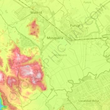
Name: Mosquera topographic map, elevation, terrain.
Average elevation: 2,570 m
Minimum elevation: 2,333 m
Maximum elevation: 2,856 m
Make a donation
Other topographic maps
Click on a map to view its topography, its elevation and its terrain.
Tunja
Tunja has a population of 172,548 inhabitants according to the 2018 Census. 0.1% of the city is indigenous, 0.4% is black, and 99.5% is white and Mestizo. It is located in central Colombia, at an elevation ranging from approximately 2,700 metres (8,900 ft) to 2,900 metres (9,500 ft). The city centre is at an…
Average elevation: 2,824 m
Pacho
Pacho is a municipality and town of Colombia in the department of Cundinamarca. Pacho is part of the Rionegro Province and the urban centre is situated at a distance of 88 kilometres (55 mi) from the capital Bogotá at an altitude of 2,136 metres (7,008 ft), while the altitude ranges from 1,000 metres (3,300…
Average elevation: 1,881 m
Make a donation
Make a donation
Make a donation