
Thank you for supporting this site ❤️
Make a donation
Make a donation
Llanhennock topographic map
Click on the map to display elevation.
Thank you for supporting this site ❤️
Make a donation
Make a donation
About this map
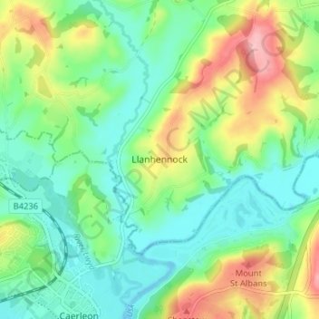
Name: Llanhennock topographic map, elevation, terrain.
Location: Llanhennock, Monmouthshire, Wales, NP18 1LT, United Kingdom (51.60912 -2.95779 51.64912 -2.91779)
Average elevation: 45 m
Minimum elevation: 0 m
Maximum elevation: 135 m
Thank you for supporting this site ❤️
Make a donation
Make a donation
Other topographic maps
Click on a map to view its topography, its elevation and its terrain.
Thank you for supporting this site ❤️
Make a donation
Make a donation
Thank you for supporting this site ❤️
Make a donation
Make a donation