
Hamam topographic map
Interactive map
Click on the map to display elevation.
About this map
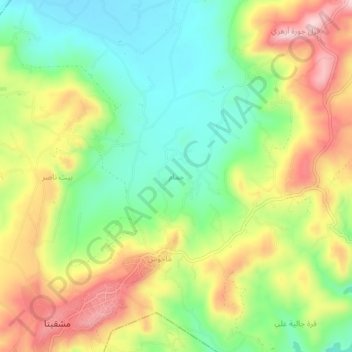
Name: Hamam topographic map, elevation, terrain.
Average elevation: 147 m
Minimum elevation: 37 m
Maximum elevation: 291 m
Other topographic maps
Click on a map to view its topography, its elevation and its terrain.
Rabia
Syrie > Gouvernorat de Lattaquié > Rabia
Rabia, ناحية ربيعة, منطقة اللاذقية, Gouvernorat de Lattaquié, Syrie
Average elevation: 403 m
Al Bibar
Syrie > Gouvernorat de Lattaquié > Marj az Zawiyah
Al Bibar, Marj az Zawiyah, ناحية کنسبا, منطقة الحفة, Gouvernorat de Lattaquié, Syrie
Average elevation: 362 m