
Thank you for supporting this site ❤️
Make a donation
Make a donation
Kessingland topographic map
Click on the map to display elevation.
Thank you for supporting this site ❤️
Make a donation
Make a donation
About this map
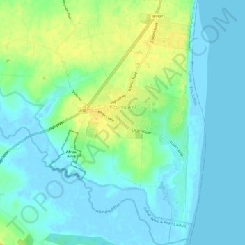
Name: Kessingland topographic map, elevation, terrain.
Location: Kessingland, East Suffolk, Suffolk, England, United Kingdom (52.39925 1.69133 52.43549 1.73232)
Average elevation: 8 m
Minimum elevation: -4 m
Maximum elevation: 24 m
Thank you for supporting this site ❤️
Make a donation
Make a donation
Other topographic maps
Click on a map to view its topography, its elevation and its terrain.
Falkenham Marshes
United Kingdom > England > Suffolk > East Suffolk > Falkenham
Average elevation: 0 m
Felixstowe Marshes
United Kingdom > England > Suffolk > East Suffolk > Felixstowe
Average elevation: 1 m
Thank you for supporting this site ❤️
Make a donation
Make a donation