
La Genevraie topographic map
Interactive map
Click on the map to display elevation.
About this map
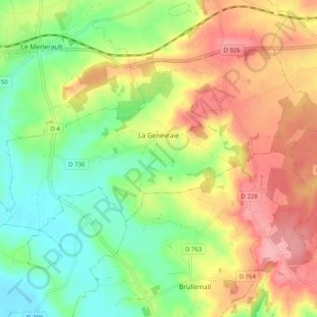
Name: La Genevraie topographic map, elevation, terrain.
Average elevation: 240 m
Minimum elevation: 181 m
Maximum elevation: 311 m
Other topographic maps
Click on a map to view its topography, its elevation and its terrain.
Coulonges-sur-Sarthe
Coulonges-sur-Sarthe, Alençon, Orne, Normandie, France métropolitaine, 61170, France
Average elevation: 168 m
La Ferté-en-Ouche
La Ferté-en-Ouche, Mortagne-au-Perche, Orne, Normandie, France métropolitaine, 61550, France
Average elevation: 241 m
La Villette
France > Normandie > Orne > Avoine
La Villette, Avoine, Argentan, Orne, Normandie, France métropolitaine, 61150, France
Average elevation: 181 m