
Le Pati topographic map
Interactive map
Click on the map to display elevation.
About this map
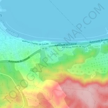
Name: Le Pati topographic map, elevation, terrain.
Average elevation: 57 m
Minimum elevation: -2 m
Maximum elevation: 189 m
Other topographic maps
Click on a map to view its topography, its elevation and its terrain.
Plateau de Figuerolles
France > Provence-Alpes-Côte d'Azur > Bouches-du-Rhône > Martigues
Plateau de Figuerolles, Allée Jean-Baptiste Clément, Martigues, Istres, Bouches-du-Rhône, Provence-Alpes-Côte d'Azur, France métropolitaine, 13500, France
Average elevation: 23 m