
Drifton topographic map
Interactive map
Click on the map to display elevation.
About this map
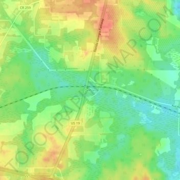
Name: Drifton topographic map, elevation, terrain.
Location: Drifton, Jefferson County, Florida, 32344, United States (30.47548 -83.89933 30.51548 -83.85933)
Average elevation: 52 m
Minimum elevation: 27 m
Maximum elevation: 78 m
Other topographic maps
Click on a map to view its topography, its elevation and its terrain.
Monticello
United States > Florida > Jefferson County
Monticello, Jefferson County, Florida, 32345, United States
Average elevation: 58 m
Ashville
United States > Florida > Jefferson County > Ashville
Ashville, Jefferson County, Florida, United States
Average elevation: 43 m