
Kleinbasel topographic map
Interactive map
Click on the map to display elevation.
About this map
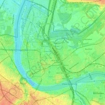
Name: Kleinbasel topographic map, elevation, terrain.
Location: Kleinbasel, Basel, Basel-Stadt, 4058, Schweiz (47.54974 7.58453 47.58974 7.62453)
Average elevation: 261 m
Minimum elevation: 243 m
Maximum elevation: 287 m
Das Kleinbasel galt als Stadtteil der «einfachen Leute», während die Basler Oberschicht in Grossbasel residierte. Noch heute gilt das Kleinbasel als Arbeiter- und Einwandererviertel (mit Ausnahme des Wettsteinquartiers, das ab den 1920er Jahren als bürgerliches Wohnviertel in der Nähe des Rheins konzipiert wurde) und hat einen weit höheren Ausländeranteil als das linksrheinische Grossbasel. Deshalb wird die Bezeichnung «minderes Basel» teilweise als abwertend empfunden, obwohl das Wort «minder» ursprünglich einfach «kleiner» und keineswegs «minderwertig» bedeutete. Das mindere Basel bedeutet also einfach der kleinere Stadtteil.
Other topographic maps
Click on a map to view its topography, its elevation and its terrain.
St. Johann
Schweiz > Basel-Stadt > Basel
St. Johann, Basel, Basel-Stadt, Schweiz
Average elevation: 265 m
Bruderholz
Schweiz > Basel-Stadt > Basel
Bruderholz, Basel, Basel-Stadt, 4059, Schweiz
Average elevation: 319 m
Altstadt Kleinbasel
Schweiz > Basel-Stadt > Basel
Altstadt Kleinbasel, Basel, Basel-Stadt, Schweiz
Average elevation: 267 m
Hirzbrunnen
Schweiz > Basel-Stadt > Basel
Hirzbrunnen, Basel, Basel-Stadt, 5068, Schweiz
Average elevation: 260 m
Bachletten
Schweiz > Basel-Stadt > Basel
Bachletten, Basel, Basel-Stadt, 4054, Schweiz
Average elevation: 292 m