
Faringdon topographic map
Interactive map
Click on the map to display elevation.
About this map
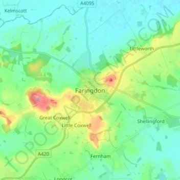
Name: Faringdon topographic map, elevation, terrain.
Average elevation: 91 m
Minimum elevation: 65 m
Maximum elevation: 174 m
Die in einer Höhe von ca. 105 m im Südosten der Cotswolds gelegene Kleinstadt Faringdon liegt etwa 2 km südlich der Themse; die Großstädte Swindon (ca. 15 km südwestlich) und Oxford (ca. 28 km nordöstlich) bilden wichtige Bezugspunkte in der Region, London liegt ungefähr 125 km (Fahrtstrecke) östlich. Die Gegend um Faringdon ist leicht hügelig und ganzjährig grün; der Waldbestand ist nicht sehr dicht. Das Klima ist eher mild, die Niederschläge (ca. 720 mm/Jahr) sind übers Jahr verteilt.
Other topographic maps
Click on a map to view its topography, its elevation and its terrain.
Great Coxwell
Vereinigtes Königreich > England > Oxfordshire > Vale of White Horse
Great Coxwell, Vale of White Horse, Oxfordshire, England, Vereinigtes Königreich
Average elevation: 108 m