
Fridingen an der Donau topographic map
Interactive map
Click on the map to display elevation.
About this map
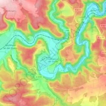
Name: Fridingen an der Donau topographic map, elevation, terrain.
Average elevation: 734 m
Minimum elevation: 602 m
Maximum elevation: 872 m
Other topographic maps
Click on a map to view its topography, its elevation and its terrain.
Brunnentäle
Alemanha > Baden-Vurtemberga > Landkreis Tuttlingen > Tuttlingen
Brunnentäle, Tuttlingen, Verwaltungsgemeinschaft Tuttlingen, Landkreis Tuttlingen, Baden-Vurtemberga, 78532, Alemanha
Average elevation: 751 m
Leipferdingen Bahnstation
Alemanha > Baden-Vurtemberga > Landkreis Tuttlingen > Geisingen > Leipferdingen > Leipferdingen Bahnstation
Leipferdingen Bahnstation, Leipferdingen, Geisingen, Verwaltungsverband Immendingen-Geisingen, Landkreis Tuttlingen, Baden-Vurtemberga, 78187, Alemanha
Average elevation: 750 m