
Borgstedt topographic map
Interactive map
Click on the map to display elevation.
About this map
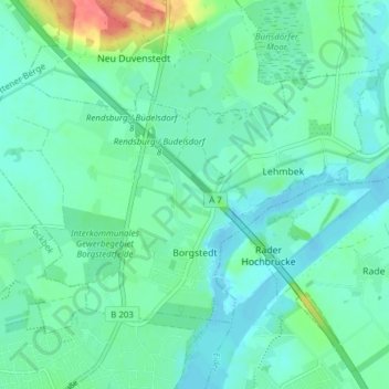
Name: Borgstedt topographic map, elevation, terrain.
Average elevation: 14 m
Minimum elevation: -2 m
Maximum elevation: 63 m
Other topographic maps
Click on a map to view its topography, its elevation and its terrain.
Loop
Germany > Schleswig-Holstein > Rendsburg-Eckernförde
Loop, Bordesholm, Rendsburg-Eckernförde, Schleswig-Holstein, Germany
Average elevation: 29 m
Fleckeby
Germany > Schleswig-Holstein > Rendsburg-Eckernförde
Fleckeby, Schlei-Ostsee, Rendsburg-Eckernförde, Schleswig-Holstein, 24357, Germany
Average elevation: 17 m
Warder
Germany > Schleswig-Holstein > Rendsburg-Eckernförde
Warder, Amt Nortorfer Land, Rendsburg-Eckernförde, Schleswig-Holstein, 24646, Germany
Average elevation: 28 m