
Fernana topographic map
Interactive map
Click on the map to display elevation.
About this map
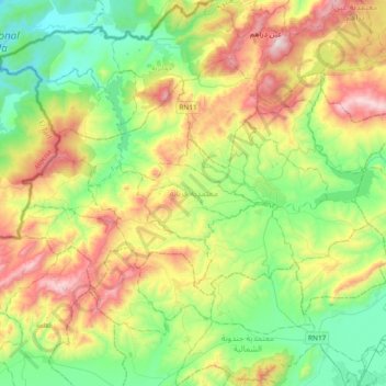
Name: Fernana topographic map, elevation, terrain.
Location: Fernana, Jendouba, 8140, Tunisie (36.55836 8.44680 36.74702 8.82233)
Average elevation: 388 m
Minimum elevation: 52 m
Maximum elevation: 1,009 m
Other topographic maps
Click on a map to view its topography, its elevation and its terrain.
Oued Mellegue
Oued Mellegue, El Malga, Jendouba Sud, Jendouba, 8100, Tunisie
Average elevation: 140 m
Barrage Beni M'Tir
Barrage Beni M'Tir, Avenue de la Terre, Aïn Draham, El Fraijia, Aïn Draham, Jendouba, 9029, Tunisie
Average elevation: 500 m