
Arimbur topographic map
Interactive map
Click on the map to display elevation.
About this map
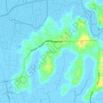
Name: Arimbur topographic map, elevation, terrain.
Location: Arimbur, Thrissur, Thrissur District, Kerala, 680620, India (10.47356 76.12723 10.51356 76.16723)
Average elevation: 3 m
Minimum elevation: -7 m
Maximum elevation: 25 m
Other topographic maps
Click on a map to view its topography, its elevation and its terrain.
Kulam -Balakrishnan,Karamangattil, Chazhoor, Chetakulam
India > Kerala > Thrissur > Puthenpeedika
Average elevation: 6 m