
Thank you for supporting this site ❤️
Make a donation
Make a donation
Marion County Lake topographic map
Click on the map to display elevation.
Thank you for supporting this site ❤️
Make a donation
Make a donation
About this map
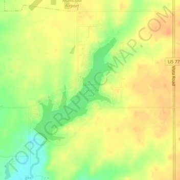
Name: Marion County Lake topographic map, elevation, terrain.
Location: Marion County Lake, Marion County, Kansas, United States (38.31393 -96.99334 38.32974 -96.97758)
Average elevation: 419 m
Minimum elevation: 395 m
Maximum elevation: 432 m
Thank you for supporting this site ❤️
Make a donation
Make a donation
Other topographic maps
Click on a map to view its topography, its elevation and its terrain.