
Thank you for supporting this site ❤️
Make a donation
Make a donation
Gunnarsbo topographic map
Click on the map to display elevation.
Thank you for supporting this site ❤️
Make a donation
Make a donation
About this map
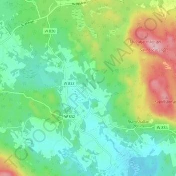
Name: Gunnarsbo topographic map, elevation, terrain.
Location: Gunnarsbo, Falun, Falu kommun, Dalarna County, 791 93, Sweden (60.54536 15.48235 60.58536 15.52235)
Average elevation: 161 m
Minimum elevation: 109 m
Maximum elevation: 273 m
Thank you for supporting this site ❤️
Make a donation
Make a donation