
Ichchapuram topographic map
Interactive map
Click on the map to display elevation.
About this map
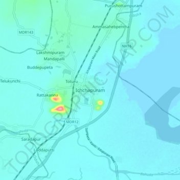
Name: Ichchapuram topographic map, elevation, terrain.
Location: Ichchapuram, Srikakulam, Andhra Pradesh, 532312, India (19.07270 84.64872 19.15270 84.72872)
Average elevation: 10 m
Minimum elevation: -1 m
Maximum elevation: 137 m
Other topographic maps
Click on a map to view its topography, its elevation and its terrain.
Bhimapur
India > Andhra Pradesh > Ichchapuram > Bhimapur
Bhimapur, Ichchapuram, Srikakulam, Andhra Pradesh, 761004, India
Average elevation: 20 m