
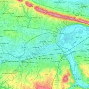
Bad Oeynhausen topographic map
Interactive map
Click on the map to display elevation.
About this map
Name: Bad Oeynhausen topographic map, elevation, terrain.
Average elevation: 94 m
Minimum elevation: 38 m
Maximum elevation: 264 m
Other topographic maps
Click on a map to view its topography, its elevation and its terrain.
Gut Renkhausen
Duitsland > Noordrijn-Westfalen > Kreis Minden-Lübbecke > Lübbecke
Gut Renkhausen, 1, Renkhauser Allee, Gehlenbeck, Lübbecke, Kreis Minden-Lübbecke, Noordrijn-Westfalen, 32312, Duitsland
Average elevation: 55 m
Petershagen
Duitsland > Noordrijn-Westfalen > Kreis Minden-Lübbecke
Petershagen, Kreis Minden-Lübbecke, Noordrijn-Westfalen, 32469, Duitsland
Average elevation: 48 m
Windheim
Duitsland > Noordrijn-Westfalen > Kreis Minden-Lübbecke > Petershagen
Windheim, Petershagen, Kreis Minden-Lübbecke, Noordrijn-Westfalen, 32469, Duitsland
Average elevation: 39 m