
Palm Harbor topographic map
Interactive map
Click on the map to display elevation.
About this map
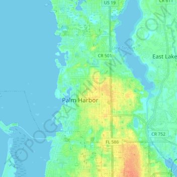
Name: Palm Harbor topographic map, elevation, terrain.
Average elevation: 7 m
Minimum elevation: -2 m
Maximum elevation: 34 m
Other topographic maps
Click on a map to view its topography, its elevation and its terrain.
A.L. Anderson Park
United States > Florida > Pinellas County > Tarpon Springs
A.L. Anderson Park, 39699, Tarpon Springs, Pinellas County, Florida, 34689, United States
Average elevation: 5 m
Lake Tarpon
United States > Florida > Pinellas County > Tarpon Springs
Lake Tarpon, Tarpon Springs, Pinellas County, Florida, United States
Average elevation: 8 m