
Portlligat topographic map
Interactive map
Click on the map to display elevation.
About this map
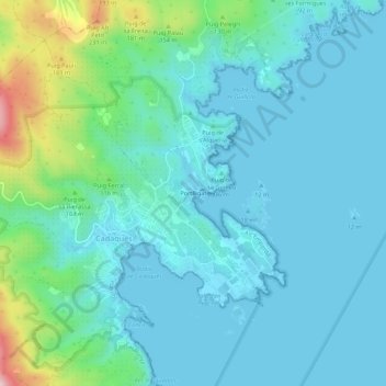
Name: Portlligat topographic map, elevation, terrain.
Average elevation: 50 m
Minimum elevation: 0 m
Maximum elevation: 291 m
Other topographic maps
Click on a map to view its topography, its elevation and its terrain.
Far del Cap de Creus
Espagne > Catalogne > Haut-Ampurdan > Cadaqués
Far del Cap de Creus, Carretera al Cap de Creus, Cadaqués, Haut-Ampurdan, Gérone, Catalogne, 17488, Espagne
Average elevation: 10 m