
Thank you for supporting this site ❤️
Make a donation
Make a donation
Le Grand Villard topographic map
Click on the map to display elevation.
Thank you for supporting this site ❤️
Make a donation
Make a donation
About this map
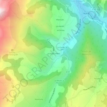
Name: Le Grand Villard topographic map, elevation, terrain.
Average elevation: 1,346 m
Minimum elevation: 1,027 m
Maximum elevation: 1,854 m
Thank you for supporting this site ❤️
Make a donation
Make a donation
Other topographic maps
Click on a map to view its topography, its elevation and its terrain.
Montagne de Faraut
France > Provence-Alpes-Côte d'Azur > Hautes-Alpes > Le Dévoluy
Average elevation: 1,448 m
Saint-Disdier
France > Provence-Alpes-Côte d'Azur > Hautes-Alpes > Le Dévoluy
Average elevation: 1,614 m