
Château topographic map
Interactive map
Click on the map to display elevation.
About this map
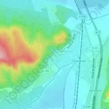
Name: Château topographic map, elevation, terrain.
Average elevation: 137 m
Minimum elevation: 97 m
Maximum elevation: 277 m
Other topographic maps
Click on a map to view its topography, its elevation and its terrain.
Le Géant de Provence (Platane)
France > Provence-Alpes-Côte d'Azur > Bouches-du-Rhône > Lamanon
Le Géant de Provence (Platane), Rue du Canal, Lotissement de Calès, Lamanon, Aix-en-Provence, Bouches-du-Rhône, Provence-Alpes-Côte d'Azur, France métropolitaine, 13113, France
Average elevation: 135 m