
Waterloo topographic map
Interactive map
Click on the map to display elevation.
About this map
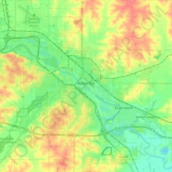
Name: Waterloo topographic map, elevation, terrain.
Average elevation: 272 m
Minimum elevation: 246 m
Maximum elevation: 307 m
Other topographic maps
Click on a map to view its topography, its elevation and its terrain.
Waterloo
Vereinigte Staaten von Amerika > Iowa > Black Hawk County > Waterloo
Waterloo, Black Hawk County, Iowa, 50701-1334, Vereinigte Staaten von Amerika
Average elevation: 282 m