
Campos topographic map
Interactive map
Click on the map to display elevation.
About this map
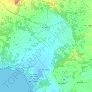
Name: Campos topographic map, elevation, terrain.
Location: Campos, Migjorn, Îles Baléares, Espagne (39.32507 2.93091 39.47644 3.10078)
Average elevation: 44 m
Minimum elevation: -3 m
Maximum elevation: 256 m
Other topographic maps
Click on a map to view its topography, its elevation and its terrain.
Cala Marçal
Espagne > Îles Baléares > Migjorn > Felanitx
Cala Marçal, Felanitx, Migjorn, Îles Baléares, 07670, Espagne
Average elevation: 17 m
Calonge
Espagne > Îles Baléares > Migjorn > Santanyí
Calonge, Santanyí, Migjorn, Îles Baléares, 07669, Espagne
Average elevation: 82 m
Colònia de Sant Jordi
Espagne > Îles Baléares > Migjorn > ses Salines > Colònia de Sant Jordi
Colònia de Sant Jordi, ses Salines, Migjorn, Îles Baléares, 07638, Espagne
Average elevation: 4 m
Santanyí
Espagne > Îles Baléares > Migjorn > Santanyí
Santanyí, Migjorn, Îles Baléares, Espagne
Average elevation: 36 m