
Haikou City topographic map
Interactive map
Click on the map to display elevation.
About this map
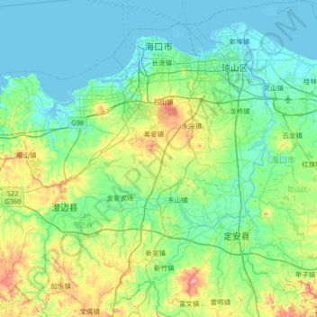
Name: Haikou City topographic map, elevation, terrain.
Location: Haikou City, Hainan Province, China (19.52594 110.10308 20.13217 110.70807)
Average elevation: 40 m
Minimum elevation: -3 m
Maximum elevation: 203 m
Other topographic maps
Click on a map to view its topography, its elevation and its terrain.
Dongfang City
China > Hainan Province > Dongfang City
Dongfang City, Hainan Province, China
Average elevation: 73 m