
Helcmanovce topographic map
Interactive map
Click on the map to display elevation.
About this map
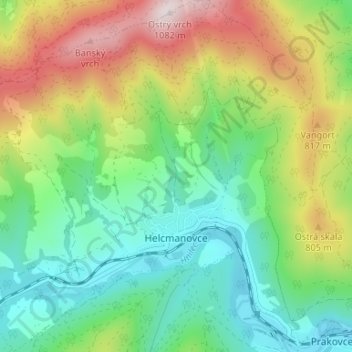
Name: Helcmanovce topographic map, elevation, terrain.
Average elevation: 618 m
Minimum elevation: 376 m
Maximum elevation: 1,067 m
Other topographic maps
Click on a map to view its topography, its elevation and its terrain.
Zahájnica
Slovakia > Region of Košice > District of Gelnica > Nálepkovo
Zahájnica, Nálepkovo, District of Gelnica, Region of Košice, Eastern Slovakia, 053 33, Slovakia
Average elevation: 673 m
Nálepkovo
Slovakia > Region of Košice > District of Gelnica
Nálepkovo, District of Gelnica, Region of Košice, Eastern Slovakia, 053 33, Slovakia
Average elevation: 745 m
Veľký Folkmar
Slovakia > Region of Košice > District of Gelnica
Veľký Folkmar, District of Gelnica, Region of Košice, Eastern Slovakia, 055 51, Slovakia
Average elevation: 551 m
Turzovské kúpele
Slovakia > Region of Košice > District of Gelnica > Gelnica
Turzovské kúpele, Gelnica, District of Gelnica, Region of Košice, Eastern Slovakia, 055 71, Slovakia
Average elevation: 649 m