
Roaguía topographic map
Interactive map
Click on the map to display elevation.
About this map
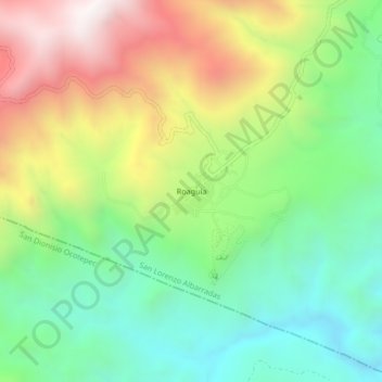
Name: Roaguía topographic map, elevation, terrain.
Location: Roaguía, San Lorenzo Albarradas, Oaxaca, México (16.85250 -96.29944 16.89250 -96.25944)
Average elevation: 1,789 m
Minimum elevation: 1,325 m
Maximum elevation: 2,507 m
Other topographic maps
Click on a map to view its topography, its elevation and its terrain.
Hierve El Agua
México > Oaxaca > San Lorenzo Albarradas > Roaguía
Hierve El Agua, Calle Zapata, Roaguía, San Lorenzo Albarradas, Oaxaca, México
Average elevation: 1,624 m