
Thank you for supporting this site ❤️
Make a donation
Make a donation
Seyssinet-Pariset topographic map
Click on the map to display elevation.
Thank you for supporting this site ❤️
Make a donation
Make a donation
Seyssinet-Pariset
Ses habitants sont appelés les Seyssinettois. La mairie est située à 215 m d'altitude et le centre du hameau de Pariset est situé à 650 m d'altitude.
Thank you for supporting this site ❤️
Make a donation
Make a donation
About this map
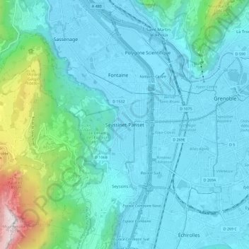
Name: Seyssinet-Pariset topographic map, elevation, terrain.
Average elevation: 444 m
Minimum elevation: 201 m
Maximum elevation: 1,889 m
Thank you for supporting this site ❤️
Make a donation
Make a donation
Other topographic maps
Click on a map to view its topography, its elevation and its terrain.
Avenue Hector Berlioz
France > Auvergne-Rhône-Alpes > Seyssinet-Pariset > Seyssinet-Pariset
Average elevation: 302 m