Geolocate

Martinsville topographic map

Interactive map

Click on the map to display elevation.

About this map

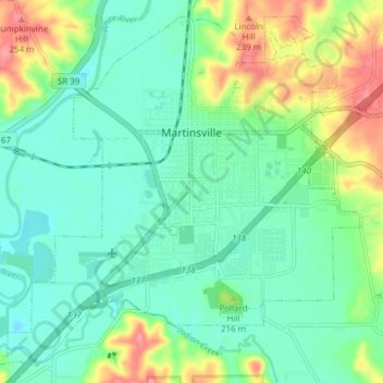
Name: Martinsville topographic map, elevation, terrain.

Location: Martinsville, Morgan County, Indiana, United States (39.39187 -86.47070 39.44573 -86.39447)

Average elevation: 197 m

Minimum elevation: 171 m

Maximum elevation: 254 m

Other topographic maps

Click on a map to view its topography, its elevation and its terrain.

Paragon

United States > Indiana > Morgan County

Paragon, Morgan County, Indiana, United States

Average elevation: 176 m

Landersdale

United States > Indiana > Morgan County

Landersdale, Morgan County, Indiana, 46183, United States

Average elevation: 211 m

Morgantown

United States > Indiana > Morgan County

Morgantown, Morgan County, Indiana, United States

Average elevation: 209 m

Brookmoor

United States > Indiana > Morgan County > Mooresville

Brookmoor, Mooresville, Morgan County, Indiana, 46158, United States

Average elevation: 215 m

Mooresville

United States > Indiana > Morgan County

Mooresville, Morgan County, Indiana, United States

Average elevation: 223 m

Monrovia

United States > Indiana > Morgan County

Monrovia, Morgan County, Indiana, United States

Average elevation: 237 m