
Coshocton County topographic map
Interactive map
Click on the map to display elevation.
About this map
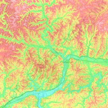
Name: Coshocton County topographic map, elevation, terrain.
Location: Coshocton County, Ohio, États-Unis d'Amérique (40.15172 -82.19591 40.45646 -81.61647)
Average elevation: 294 m
Minimum elevation: 213 m
Maximum elevation: 404 m
Other topographic maps
Click on a map to view its topography, its elevation and its terrain.
Pearl
États-Unis d'Amérique > Ohio > Coshocton County
Pearl, White Eyes Township, Coshocton County, Ohio, 43824, États-Unis d'Amérique
Average elevation: 291 m
Cavallo
États-Unis d'Amérique > Ohio > Coshocton County > Cavallo
Cavallo, Tiverton Township, Coshocton County, Ohio, États-Unis d'Amérique
Average elevation: 317 m