
Thank you for supporting this site ❤️
Make a donation
Make a donation
Huangpi District topographic map
Click on the map to display elevation.
Thank you for supporting this site ❤️
Make a donation
Make a donation
About this map
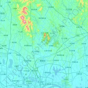
Name: Huangpi District topographic map, elevation, terrain.
Location: Huangpi District, Wuhan, Hubei, China (30.66740 114.15196 31.36224 114.61583)
Average elevation: 64 m
Minimum elevation: 13 m
Maximum elevation: 817 m
Thank you for supporting this site ❤️
Make a donation
Make a donation
Other topographic maps
Click on a map to view its topography, its elevation and its terrain.