
Make a donation
El Hierro topographic map
Click on the map to display elevation.
Make a donation
About this map
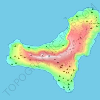
Name: El Hierro topographic map, elevation, terrain.
Location: El Hierro, Santa Cruz de Tenerife, Canary Islands, Spain (27.63774 -18.16118 27.84985 -17.88281)
Average elevation: 210 m
Minimum elevation: 0 m
Maximum elevation: 1,498 m
Make a donation
Other topographic maps
Click on a map to view its topography, its elevation and its terrain.
Granada
Spain > Andalusia > Granada > Granada
Granada (/ɡrəˈnɑːdə/ grə-NAH-də, Spanish: , locally ) is the capital city of the province of Granada, in the autonomous community of Andalusia, Spain. Granada is located at the foot of the Sierra Nevada mountains, at the confluence of four rivers, the Darro, the Genil, the Monachil and the Beiro.…
Average elevation: 1,043 m
Zaragoza
On 1 January 2019 the population of the municipality of Zaragoza was 706,904, (the fifth most populated in Spain) on a land area of 973.78 square kilometres (375.98 square miles). The population of the metropolitan area was estimated in 2006 at 783,763 inhabitants. The municipality is home to more than 50…
Average elevation: 310 m
Make a donation
Make a donation
Donostia / San Sebastián
Spain > Autonomous Community of the Basque Country > Donostialdea > Donostia / San Sebastián
Average elevation: 134 m
Make a donation
Sierra Nevada
Spain > Andalusia > Comarca de Guadix
Parts of the range have been included in the Sierra Nevada National Park. The range has also been declared a biosphere reserve. The Sierra Nevada Observatory, the Calar Alto Observatory, and the IRAM 30m telescope are located on the northern slopes at an elevation of 2,800 metres (9,200 ft).
Average elevation: 1,310 m
Make a donation
Make a donation
Make a donation
Make a donation
Make a donation
Make a donation
Las Vegas
Spain > Navarre > Estellerriko Erribera / Ribera Estellesa > Lazagurría
Average elevation: 405 m
Make a donation
Make a donation
Make a donation
Make a donation
Unza
Spain > Autonomous Community of the Basque Country > Añanako kuadrilla/Cuadrilla de Añana > Zuhatzu Kuartango
Average elevation: 793 m
Make a donation
Santa Margarita
Spain > Andalusia > Campo de Gibraltar > La Línea de la Concepción
Average elevation: 63 m
Foz de Arbaiun / Arbaiungo arroila
Spain > Zangozerria / Comarca de Sangüesa > Romanzado/Erromantzatua
Average elevation: 675 m
Make a donation
Make a donation
sa Calobra
Spain > Balearic Islands > Serra de Tramuntana > Escorca
The port village is a popular destination for coach trips and road cyclists. It is accessed by a single winding road, designed by Italian-Spanish engineer Antonio Parietti and opened in 1933, which features many hairpin bends and a 270° spiral bridge called the tie knot. The climb is officially called the…
Average elevation: 256 m
Make a donation
Sierra Nevada
Spain > Andalusia > Comarca de la Alpujarra Granadina > Lanjarón
Average elevation: 2,223 m
Make a donation
Make a donation
Río de la Toba
Spain > Andalusia > Comarca de la Costa Granadina > Los Guájares
Average elevation: 316 m
Make a donation
Make a donation
Make a donation
Make a donation
Desert de les Palmes
Spain > Valencian Community > Castelló / Castellón > Benicàssim / Benicasim
Average elevation: 370 m
Make a donation
Make a donation