
Rao topographic map
Interactive map
Click on the map to display elevation.
About this map
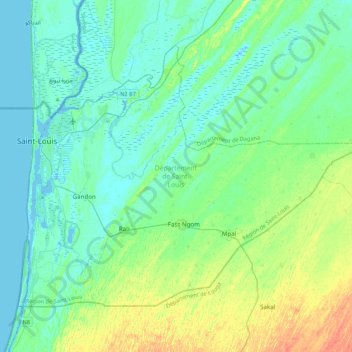
Name: Rao topographic map, elevation, terrain.
Location: Rao, Saint-Louis, Saint-Louis Region, Senegal (15.83189 -16.52745 16.14097 -16.09553)
Average elevation: 9 m
Minimum elevation: -2 m
Maximum elevation: 34 m
Other topographic maps
Click on a map to view its topography, its elevation and its terrain.
Parc national des oiseaux du Djoudj
Senegal > Saint-Louis > Diama Yalar
Parc national des oiseaux du Djoudj, Diama Yalar, Ndiaye, Dagana, Saint-Louis, Saint-Louis Region, Senegal
Average elevation: 3 m