
Make a donation
Shepperton topographic map
Click on the map to display elevation.
Make a donation
Shepperton
Shepperton has a long boundary with the River Thames in its southernmost salient, which almost surrounds Spelthorne. Old Shepperton is almost surrounded by the extreme southern meander within this. Prehistoric glacial retreat north of this has made the north bank almost flat for a considerable distance and as such, elevation never exceeds 14 m above mean sea level (on the border of Laleham). The river never exceeds 11.5 m, (beside Dumsey Meadow and under Chertsey Bridge). The lowest elevation is 9 m in flood meadows at the confluence of the Ash with the Thames. The Ash is the border with Littleton and Sunbury-on-Thames (mostly, to the northeast, with its technical hamlet, Upper Halliford).
Make a donation
About this map
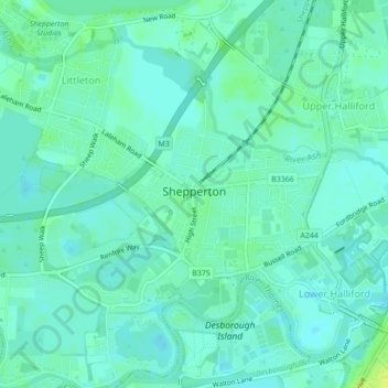
Name: Shepperton topographic map, elevation, terrain.
Average elevation: 12 m
Minimum elevation: 7 m
Maximum elevation: 23 m
Make a donation
Other topographic maps
Click on a map to view its topography, its elevation and its terrain.
Upper Halliford
United Kingdom > England > Surrey > Borough of Spelthorne
Based on 1841 census statistics, Samuel Lewis (publisher) in his 1848 A topographical guide to England stated the population of the parish of Sunbury which included Charlton and Upper Halliford, an area of 2,580 acres (1,040 ha) was 1,828.
Average elevation: 13 m
Make a donation
Queen Mary Reservoir
United Kingdom > England > Surrey > Borough of Spelthorne > Charlton
Average elevation: 14 m
Staines-upon-Thames
United Kingdom > England > Surrey > Borough of Spelthorne
Much of the town is built on gravel "islands" that rise above the low-lying floodplains of the Thames and Colne. These gravel deposits have a typical maximum elevation of 14 m (46 ft) above ordnance datum (AOD) and are as little as 0.5 m (1.6 ft) above the surrounding floodplain. Staines High Street, oriented…
Average elevation: 20 m
Make a donation
Sunbury Court Island
United Kingdom > England > Surrey > Borough of Spelthorne
Average elevation: 13 m