
Thank you for supporting this site ❤️
Make a donation
Make a donation
Llantrisant topographic map
Click on the map to display elevation.
Thank you for supporting this site ❤️
Make a donation
Make a donation
Llantrisant
Llantrisant (Welsh pronunciation: [ɬanˈtrɪsant]; "Parish of the Three Saints") is a town and community in the county borough of Rhondda Cynon Taf, Wales. It lies within the historic county boundaries of Glamorgan, on the River Ely and the Afon Clun. The three saints of the town's name are Illtyd, Gwynno, and Dyfodwg. Llantrisant is a hilltop settlement, at an altitude of 174 m (571 ft) above sea level. The town is home to the Royal Mint.
Thank you for supporting this site ❤️
Make a donation
Make a donation
About this map
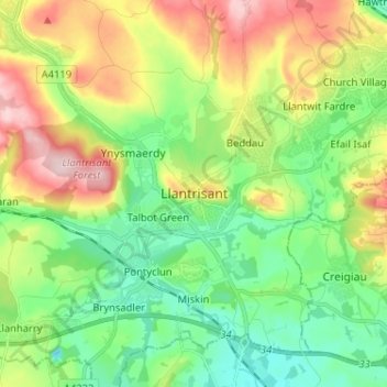
Name: Llantrisant topographic map, elevation, terrain.
Average elevation: 104 m
Minimum elevation: 16 m
Maximum elevation: 258 m
Thank you for supporting this site ❤️
Make a donation
Make a donation
Other topographic maps
Click on a map to view its topography, its elevation and its terrain.
Thank you for supporting this site ❤️
Make a donation
Make a donation
Thank you for supporting this site ❤️
Make a donation
Make a donation