
Tuxtla Gutiérrez topographic map
Interactive map
Click on the map to display elevation.
About this map
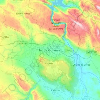
Name: Tuxtla Gutiérrez topographic map, elevation, terrain.
Location: Tuxtla Gutiérrez, Chiapas, 29019, México (16.59380 -93.27596 16.91380 -92.95596)
Average elevation: 817 m
Minimum elevation: 377 m
Maximum elevation: 1,745 m
Other topographic maps
Click on a map to view its topography, its elevation and its terrain.
Cañón del Sumidero
México > Chiapas > Tuxtla Gutiérrez > Tuxtla Gutiérrez
Cañón del Sumidero, Tuxtla Gutiérrez, Chiapas, México
Average elevation: 1,097 m
Montes Azules
México > Chiapas > Tuxtla Gutiérrez > Terán > Montes Azules
Montes Azules, Terán, Tuxtla Gutiérrez, Chiapas, 29020, México
Average elevation: 655 m