
Salou topographic map
Interactive map
Click on the map to display elevation.
About this map
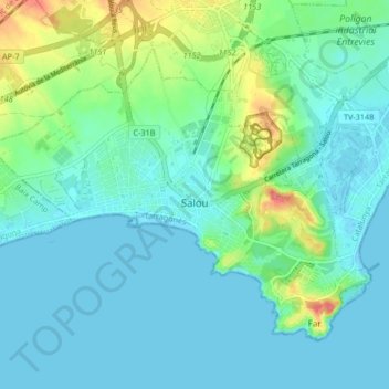
Name: Salou topographic map, elevation, terrain.
Location: Salou, Tarragonais, Tarragone, Catalogne, 43840, Espagne (41.05460 1.10059 41.10170 1.18334)
Average elevation: 14 m
Minimum elevation: -1 m
Maximum elevation: 67 m
Other topographic maps
Click on a map to view its topography, its elevation and its terrain.
Tarragone
Espagne > Catalogne > Tarragonais
Tarragone, Tarragonais, Tarragone, Catalogne, 43001, Espagne
Average elevation: 41 m
Vila-seca
Espagne > Catalogne > Tarragonais
Vila-seca, Tarragonais, Tarragone, Catalogne, 43480, Espagne
Average elevation: 32 m