
Thank you for supporting this site ❤️
Make a donation
Make a donation
Burnside topographic map
Click on the map to display elevation.
Thank you for supporting this site ❤️
Make a donation
Make a donation
About this map
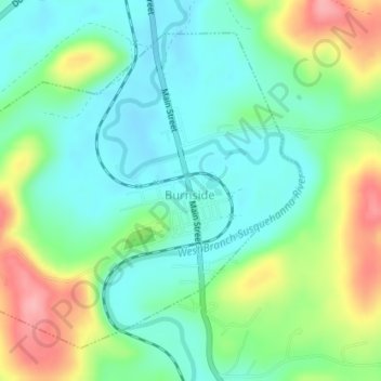
Name: Burnside topographic map, elevation, terrain.
Average elevation: 434 m
Minimum elevation: 393 m
Maximum elevation: 518 m
Thank you for supporting this site ❤️
Make a donation
Make a donation
Other topographic maps
Click on a map to view its topography, its elevation and its terrain.
Thank you for supporting this site ❤️
Make a donation
Make a donation
Morrisdale
United States > Pennsylvania > Clearfield County > Morris Township
Average elevation: 486 m
Thank you for supporting this site ❤️
Make a donation
Make a donation
Pottersdale
United States > Pennsylvania > Clearfield County > Karthaus Township
Average elevation: 394 m
Thank you for supporting this site ❤️
Make a donation
Make a donation
Frenchville
United States > Pennsylvania > Clearfield County > Covington Township
Average elevation: 438 m
Mount Hope
United States > Pennsylvania > Clearfield County > Lawrence Township
Average elevation: 419 m
Thank you for supporting this site ❤️
Make a donation
Make a donation
Utahville
United States > Pennsylvania > Clearfield County > Beccaria Township > Utahville
Average elevation: 503 m