
Make a donation
Guatemala City topographic map
Click on the map to display elevation.
Make a donation
Guatemala City
As it is in the tropics, Guatemala City has a tropical savannah climate (Köppen Aw) bordering on a more temperate humid subtropical climate (Cwa/Cwb) due to its relatively high altitude. Guatemala City is generally very warm, almost springlike, throughout the year.
Make a donation
About this map
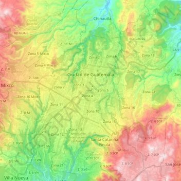
Name: Guatemala City topographic map, elevation, terrain.
Location: Guatemala City, Zona 11, Guatemala Department, Guatemala (14.53641 -90.58709 14.71379 -90.38541)
Average elevation: 1,531 m
Minimum elevation: 1,164 m
Maximum elevation: 2,017 m
Make a donation
Other topographic maps
Click on a map to view its topography, its elevation and its terrain.
Colonia Villa de San Juan
Guatemala > Guatemala Department > Guatemala City
Average elevation: 1,535 m
Santa Catarina Pinula
Guatemala > Guatemala Department > Santa Catarina Pinula
Average elevation: 1,581 m
Make a donation
Make a donation