
Thank you for supporting this site ❤️
Make a donation
Make a donation
Samudrapur topographic map
Click on the map to display elevation.
Thank you for supporting this site ❤️
Make a donation
Make a donation
About this map
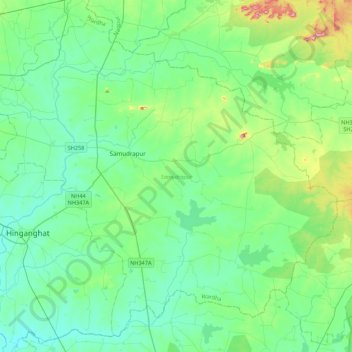
Name: Samudrapur topographic map, elevation, terrain.
Location: Samudrapur, Wardha, Maharashtra, 442305, India (20.42898 78.78914 20.79776 79.22200)
Average elevation: 243 m
Minimum elevation: 201 m
Maximum elevation: 407 m
Thank you for supporting this site ❤️
Make a donation
Make a donation
Other topographic maps
Click on a map to view its topography, its elevation and its terrain.