
L'Aquila topographic map
Interactive map
Click on the map to display elevation.
About this map
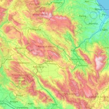
Name: L'Aquila topographic map, elevation, terrain.
Location: L'Aquila, Abruzzo, Italy (41.68204 13.01897 42.59128 14.22974)
Average elevation: 940 m
Minimum elevation: -1 m
Maximum elevation: 2,823 m
The Rocca Calascio is a mountaintop fortress or rocca in the municipality of Calascio. At an elevation of 1,512 metres (4,961 ft), the castle is the highest fortress in the Apennines. Built of stone and masonry exclusively for military purposes and intended only to accommodate troops and never as residence for nobles, the fortress overlooks the Plain of Navelli at one of the highest points in the ancient Barony of Carapelle.
Other topographic maps
Click on a map to view its topography, its elevation and its terrain.
Roccascalegna
Italy > Abruzzo > Roccascalegna > Roccascalegna
Roccascalegna, Chieti, Abruzzo, Italy
Average elevation: 367 m