
Make a donation
Štrba topographic map
Click on the map to display elevation.
Make a donation
Štrba
The municipality lies at an altitude of 829 metres and covers an area of 43.463 km². It has a population of 3,653 people. Its detached borough of Tatranská Štrba hosts the Štrba railway station, the valley terminus of the Štrbské Pleso–Štrba rack railway, and a stop on one of Slovakia's major railways. The mountain resort settlement of Štrbské Pleso also belongs to the village.
Make a donation
About this map
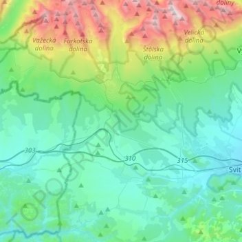
Name: Štrba topographic map, elevation, terrain.
Location: Štrba, District of Poprad, Region of Prešov, Slovakia (49.00910 20.01286 49.17239 20.11123)
Average elevation: 1,134 m
Minimum elevation: 725 m
Maximum elevation: 2,617 m
Make a donation
Other topographic maps
Click on a map to view its topography, its elevation and its terrain.
Czerwone Wierchy / Červené vrchy
Slovakia > Region of Prešov > District of Poprad > Vysoké Tatry
Average elevation: 1,730 m
Tatranská Lomnica
Slovakia > Region of Prešov > District of Poprad > Vysoké Tatry
Average elevation: 915 m
Vysoké Tatry - Starý Smokovec
Slovakia > Region of Prešov > District of Poprad > Vysoké Tatry
Average elevation: 1,069 m
Vysoké Tatry - Tatranské Matliare
Slovakia > Region of Prešov > District of Poprad > Vysoké Tatry
Average elevation: 900 m
Make a donation
Poprad
Slovakia > Region of Prešov > District of Poprad > Poprad > Poprad
International Poprad–Tatry Airport from 1938, is an airport with the highest elevations in Central Europe. It also offers scheduled flights to London.
Average elevation: 699 m