
Thank you for supporting this site ❤️
Make a donation
Make a donation
Saxtons River topographic map
Click on the map to display elevation.
Thank you for supporting this site ❤️
Make a donation
Make a donation
Saxtons River
The Saxtons River is a 22.9-mile-long (36.9 km) river in the U.S. state of Vermont, a tributary of the Connecticut River. Its watershed covers 78 square miles (200 km2) and a range in altitude of 1,800 feet (550 m); land use is about 80% forested and 3% agricultural, and the upper river supports wild brook trout and brown trout, while Atlantic salmon occur but are usually limited to the area below Twin Falls on the lower river.
Thank you for supporting this site ❤️
Make a donation
Make a donation
About this map
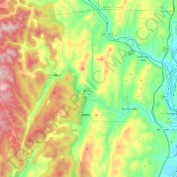
Name: Saxtons River topographic map, elevation, terrain.
Average elevation: 321 m
Minimum elevation: 66 m
Maximum elevation: 689 m
Thank you for supporting this site ❤️
Make a donation
Make a donation