
Platteville topographic map
Interactive map
Click on the map to display elevation.
About this map
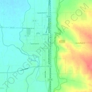
Name: Platteville topographic map, elevation, terrain.
Location: Platteville, Weld County, Colorado, États-Unis d'Amérique (40.19948 -104.86751 40.23264 -104.81056)
Average elevation: 1,475 m
Minimum elevation: 1,454 m
Maximum elevation: 1,516 m
Other topographic maps
Click on a map to view its topography, its elevation and its terrain.
Windsor
États-Unis d'Amérique > Colorado > Weld County
Windsor, Weld County, Colorado, 80550, États-Unis d'Amérique
Average elevation: 1,485 m
Fort Lupton
États-Unis d'Amérique > Colorado > Weld County
Fort Lupton, Weld County, Colorado, 80621, États-Unis d'Amérique
Average elevation: 1,512 m