
Wezel topographic map
Interactive map
Click on the map to display elevation.
About this map
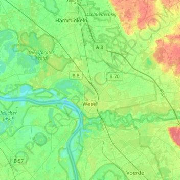
Name: Wezel topographic map, elevation, terrain.
Location: Wezel, Kreis Wesel, Noordrijn-Westfalen, Duitsland (51.61630 6.46031 51.72361 6.71373)
Average elevation: 26 m
Minimum elevation: 8 m
Maximum elevation: 63 m
Other topographic maps
Click on a map to view its topography, its elevation and its terrain.
Neukirchen-Vluyn
Duitsland > Noordrijn-Westfalen > Kreis Wesel
Neukirchen-Vluyn, Kreis Wesel, Noordrijn-Westfalen, 47506, Duitsland
Average elevation: 32 m
Neukirchen-Vluyn
Duitsland > Noordrijn-Westfalen > Kreis Wesel > Neukirchen-Vluyn > Neukirchen-Vluyn
Neukirchen-Vluyn, Kreis Wesel, Noordrijn-Westfalen, 47506, Duitsland
Average elevation: 31 m
Rheinberg
Duitsland > Noordrijn-Westfalen > Kreis Wesel > Rheinberg
Rheinberg, Kreis Wesel, Noordrijn-Westfalen, 47495, Duitsland
Average elevation: 24 m
Hünxe
Duitsland > Noordrijn-Westfalen > Kreis Wesel > Hünxe
Hünxe, Kreis Wesel, Noordrijn-Westfalen, 46569, Duitsland
Average elevation: 40 m
Xanten
Duitsland > Noordrijn-Westfalen > Kreis Wesel
Xanten, Kreis Wesel, Noordrijn-Westfalen, 46509, Duitsland
Average elevation: 24 m
Hamminkeln
Duitsland > Noordrijn-Westfalen > Kreis Wesel
Hamminkeln, Kreis Wesel, Noordrijn-Westfalen, 46499, Duitsland
Average elevation: 27 m