
Bratislava topographic map
Interactive map
Click on the map to display elevation.
Bratislava
The Carpathian mountain range begins in city territory with the Little Carpathians (Malé Karpaty). The Záhorie and Danubian lowlands stretch into Bratislava. The city's lowest point is at the Danube's surface at 126 metres (413 ft) above mean sea level, and the highest point is Devínska Kobyla at 514 metres (1,686 ft). The average altitude is 140 metres (460 ft).
About this map
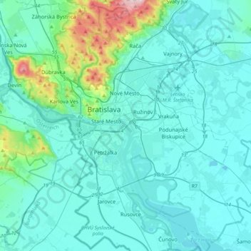
Name: Bratislava topographic map, elevation, terrain.
Location: Bratislava, Region of Bratislava, Slovakia (48.01789 16.96590 48.25455 17.24005)
Average elevation: 168 m
Minimum elevation: 118 m
Maximum elevation: 559 m
Other topographic maps
Click on a map to view its topography, its elevation and its terrain.
Bratislava
Slovakia > Region of Bratislava > District of Bratislava I > Bratislava
Average elevation: 187 m