
Thank you for supporting this site ❤️
Make a donation
Make a donation
Nová Kelča topographic map
Click on the map to display elevation.
Thank you for supporting this site ❤️
Make a donation
Make a donation
Nová Kelča
The municipality lies at an altitude of 180 metres and covers an area of 11.836 km². It has a population of about 355 people.
Thank you for supporting this site ❤️
Make a donation
Make a donation
About this map
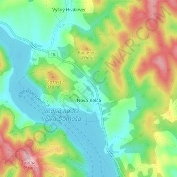
Name: Nová Kelča topographic map, elevation, terrain.
Average elevation: 230 m
Minimum elevation: 154 m
Maximum elevation: 377 m
Thank you for supporting this site ❤️
Make a donation
Make a donation
Other topographic maps
Click on a map to view its topography, its elevation and its terrain.
Jasina od Šťavia
Slovakia > Region of Prešov > District of Vranov nad Topľou > Rudlov
Average elevation: 599 m