
Harding County topographic map
Interactive map
Click on the map to display elevation.
About this map
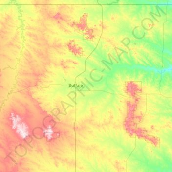
Name: Harding County topographic map, elevation, terrain.
Location: Harding County, South Dakota, United States (45.21244 -104.04544 45.94534 -102.94246)
Average elevation: 930 m
Minimum elevation: 782 m
Maximum elevation: 1,223 m
Other topographic maps
Click on a map to view its topography, its elevation and its terrain.
Badlands
United States > South Dakota > Perkins County
Badlands, Perkins County, South Dakota, United States
Average elevation: 827 m
Black Hills
United States > South Dakota > Pennington County
Black Hills, Pennington County, South Dakota, United States
Average elevation: 1,894 m
Mount Rushmore
United States > South Dakota > Pennington County
Mount Rushmore, Pennington County, South Dakota, 57751, United States
Average elevation: 1,562 m
De Smet
United States > South Dakota > Kingsbury County
De Smet, Kingsbury County, South Dakota, 57231, United States
Average elevation: 525 m
Keystone
United States > South Dakota > Pennington County
Keystone, Pennington County, South Dakota, 57751, United States
Average elevation: 1,404 m
Rapid City
United States > South Dakota > Pennington County > Rapid City
Rapid City, Pennington County, South Dakota, United States
Average elevation: 1,067 m