
Thank you for supporting this site ❤️
Make a donation
Make a donation
Beverly topographic map
Click on the map to display elevation.
Thank you for supporting this site ❤️
Make a donation
Make a donation
About this map
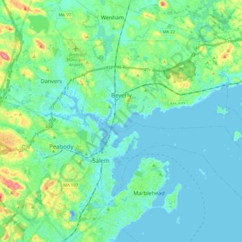
Name: Beverly topographic map, elevation, terrain.
Location: Beverly, Essex County, Massachusetts, United States (42.49394 -70.92234 42.59151 -70.72668)
Average elevation: 16 m
Minimum elevation: -22 m
Maximum elevation: 81 m
Thank you for supporting this site ❤️
Make a donation
Make a donation
Other topographic maps
Click on a map to view its topography, its elevation and its terrain.